×

The Standard e-Paper
Kenya's Bold Newspaper

An army soldier walks in front of the Republican Palace in Khartoum, Sudan, after it was taken over by Sudan’s army, March 21, 2025. [AP]
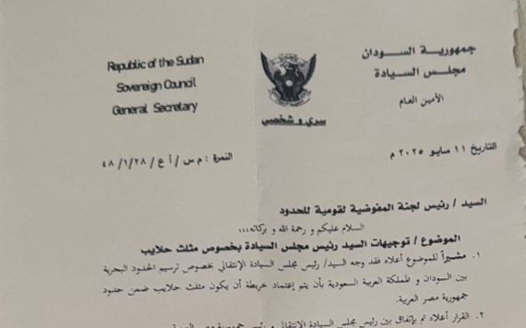
A French news website has reported that Sudan’s Sovereignty Council directed officials to adopt a new map placing the Hala’ib Triangle within Egypt’s borders, a claim that challenges the army’s public position on the decades‑long dispute.
Riso International Network cited what it described as an official document and an informed source to assert that Khartoum asked the National Border Authority to use a map recognising Egyptian control of Hala’ib, Shalateen and Abu Ramad.
The outlet reported that the step followed a meeting between President Abdel Fattah el Sisi and Sovereignty Council Chairman Lt. Gen. Abdel Fattah al Burhan and that both leaders agreed not to raise the matter before international bodies.
There was no immediate comment from authorities in Khartoum or Cairo.
Sudanese officials have previously denied recognising Egyptian sovereignty over the area while Egypt has administered the triangle since the mid-1990s.
The Hala’ib Triangle dispute dates back to colonial-era border definitions.
Egypt cites an 1899 agreement placing the area within its territory, while Sudan refers to a 1902 administrative boundary that put it under Khartoum’s control.
Egypt has rejected Sudan’s calls for international arbitration, saying both sides must consent before a tribunal can hear the case.
The triangle sits on the Red Sea and is valued for its location and resources, including minerals and fisheries.
Its status has remained a pressure point in Egypt–Sudan relations and could affect maritime border demarcation with Saudi Arabia.
Standard Digital has not seen the document cited by the French website and could not verify the claim.


Subscribe to our newsletter and stay updated on the latest developments and special offers!