The Standard Group Plc is a
multi-media organization with investments in media platforms spanning newspaper
print operations, television, radio broadcasting, digital and online services. The
Standard Group is recognized as a leading multi-media house in Kenya with a key
influence in matters of national and international interest.
For the best experience, please enable JavaScript in your browser settings.
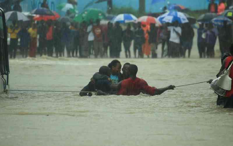
Residents struggle with floods following a downpour at Bamburi in Mombasa County on November 17, 2023. [Kelvin Karani, Standard]
Mombasa County faces a widespread flood hazard threat. This is according to a flood risk assessment report from the German Corporation for International Cooperation (GIZ).
A rapid assessment undertaken by Coastal and Marine Resources Development (COMRED) identified poor solid waste management, potable water scarcity, river management and urban flooding as the county's major adaptation issues.
Through stakeholder consultations, urban flooding emerged as the highest priority among the four issues. Its complexity and lack of obvious solutions called for a multi-sectoral, innovative, and in-depth participatory approach.
GIZ produced the publication as part of the Covenant of Mayors for Sub-Saharan Africa (CoM SSA), an initiative co-financed by the European Union (EU), German Federal Ministry for Economic Cooperation and Development (BMZ) and the Spanish Agency for International Development Cooperation (AECID).
As a signatory to the CoM SSA, the County Government of Mombasa made a voluntary political commitment to identify and address priority climate and energy issues in the county, aligning with broader policy objectives.
Following a Memorandum of Understanding (MoU) signed between the County and CoM SSA in 2022, the partners agreed to collaborate specifically on strengthening adaptation to climate change in Mombasa.
The Urban Lab approach, developed by CoM SSA in consultation with the African Centre for Cities, was identified to create solutions to combat urban flooding.
This led to the launch of the Mombasa City Lab. The City Lab is an in-depth stakeholder-led process to co-design, co-create, and implement solutions to complex challenges faced by a city, using inclusive and participatory approaches.
To lay the ground for implementing the Mombasa City Lab on urban flooding, stakeholders conducted a flood risk and vulnerability assessment.
The objective was to map the highest flood risks in the county’s jurisdiction and identify key areas on which the Mombasa City Lab should focus.
According to the report, significant areas are classified as high hazard - with approximately 29.9 per cent of the county in high, and 13.4 per cent in very high hazard areas.
Moderate flood hazard covers about 30.7 per cent of the county.
“In contrast, 7 per cent faces low risk, and 18.9 per cent has a very low flood hazard. Wards in high and very high flood hazard areas Timbwani, Shika Adabu, Majengo, Mjambere, Magongo, Kadzandani, Magogoni, Kongowea, Mikindani, Likoni, Chaani, and Junda,” said the report, which Abel Omanga, a technical advisor with GIZ, authored.
“Wards in low flood hazard areas are Jomvu Kuu, Miritini, Airport, Mtongwe and Port Reitz,” added the report.
Stay informed. Subscribe to our newsletter
In the assessment of the vulnerability to the flood disaster, the report shows that nearly 40.6 per cent of the county has low vulnerability and 12.8 per cent has very low vulnerability to floods.
Nearly a third (30.4 per cent), represent moderate vulnerability, and 9.2 per cent and 6.9 per cent of the County area represent high and very high vulnerability respectively.
"In terms of adaptive capacity, the majority of county areas (41 per cent) exhibit very high adaptive capacity, with high adaptive capacity covering 22.8 per cent," it said.
The report says moderate adaptive capacity represents 18.4 per cent, while low and very low adaptive capacities constitute 13.4 per cent and 4.3 per cent of the County area, respectively.
A notable pattern emerges when examining vulnerability and adaptive capacity, which is crucial in mitigating flood risk.
"Areas with low to very low vulnerability collectively make up 53.4 per cent of the county area, while those with high to very high adaptive capacity constitutes 63.8 per cent," said the report.
 The Standard Group Plc is a
multi-media organization with investments in media platforms spanning newspaper
print operations, television, radio broadcasting, digital and online services. The
Standard Group is recognized as a leading multi-media house in Kenya with a key
influence in matters of national and international interest.
The Standard Group Plc is a
multi-media organization with investments in media platforms spanning newspaper
print operations, television, radio broadcasting, digital and online services. The
Standard Group is recognized as a leading multi-media house in Kenya with a key
influence in matters of national and international interest.